Explore the Sectors in Queen Elizabeth National Park
Explore the Sectors in Queen Elizabeth National Park : Queen Elizabeth national park is the second largest and oldest park. It has a large bio diversity covering an estimated 1,978km2 between lakes George and Edward connected by the Kazinga channel. The park was first gazetted as Kazinga National Park in 1952. Later renamed after 2 years to commemorate the first visit of Queen Elizabeth II in Uganda. This park is divided into different sectors which harbors over 618 bird species as well as 95 mammals. Furthermore, it is covered by the savannah, wetlands and low- land forest vegetation.
Sectors in Queen Elizabeth National Park
Ishasha Sector
This sector is located in the south western part of the park well known for its tree climbing lions. These are seen hanging on the acacia and huge fig trees in the savannah grasslands because of different reasons. These include; to have clear view of their prey, run away from the insects which bite them. They also run away from the heat on the grounds as well as laze within the tree branches.
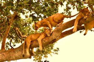 These tree climbing lions are unique creatures that are only found in Ishasha sector in Uganda and Lake Manyara National Park in Tanzania. Apart from tree climbing lions, Ishasha sector harbors 95 mammal species. These include; buffaloes, forest elephants, warthogs, waterbucks, Topi, Uganda kobs, hippos, etc. Over 618 bird species and these include; Tinker birds, Ross’ Turaco, Black bellied bustard, African crowned eagle, Yellow billed oxpecker, Stripped kingfisher. Helmeted guinea fowl, White headed barbet, Wood pecker, African green pigeon, long tailed Night jars, etc.
Accommodation in Ishasha sector
While here, there is no need of crossing over for accommodation since the park offers accommodation facilities. Accommodation here ranges from luxury, midrange as well as budget. Some of these include; Ishasha wilderness camp, Queen Elizabeth bush lodge, Ihimba lodge, etc. These provide quality services ranging from bar and restaurant with both local and international dishes, fire places, internet services, etc.
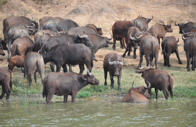
Kasenyi Plains
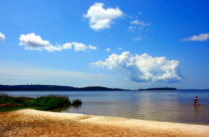
Also known as the Mweya, is located in the North Eastern part of Queen Elizabeth National Park. The plains are on the western shores of Lake George which is joined by Kazinga channel with Lake Edward. Kasenyi plains harbor numerous wild species that are clearly viewed during the game drives in the open savannah grasslands. These include; big numbers of Uganda kobs which are seen breeding, lions, buffaloes, elephants, warthogs, hyenas, etc.
Activities in the Kasenyi plains
Game drive
During the game drive, in an open roof safari vehicle within this sector, you will have a clear view of large numbers of different animals. These include; Uganda kobs, lions, elephants, buffaloes, warthogs, bushbucks, etc. Bird species include; black bellied bustard, grey capped warbler, etc. Note that, the game drive can be carried out both in the early morning, late afternoon and night drive.
Lion tracking
![]() This is one of the interesting and adventurous activity only carried out in Queen Elizabeth National park. This activity is normally carried out by a tour guide from the Uganda carnivore project under the management of Uganda wildlife Authority. He tracks the lions using radio trackers since these lions do have radio collars for easy spotting.
This is one of the interesting and adventurous activity only carried out in Queen Elizabeth National park. This activity is normally carried out by a tour guide from the Uganda carnivore project under the management of Uganda wildlife Authority. He tracks the lions using radio trackers since these lions do have radio collars for easy spotting.
However, the number of people allowed during tracking is limited to avoid scaring away the lions. Besides, you will have a chance to take a close look at them which takes about 3 hours. Furthermore, it is normally conducted twice a day either in the morning or late afternoon. Permits for lion tracking cost USD200 and members in the East African community 200,000 per person and booked in advance.
Boat cruise along the Kazinga Channel
The boat cruise along the Kazinga channel is the highlight of any Uganda safari which you can’t miss while on your trip. This activity normally takes 3-4 hours and conducted twice a day in the morning and late afternoon. In addition, it is accompanied by a professional tour guide who gives you the history of the channel and also wildlife along the shores. Therefore, feel free to ask them different questions about anything around there. You will also view different mammals such as crocodiles, hippos, elephants, buffaloes, water bucks, antelopes, etc. Also have a chance to view different bird species such as kingfishers, African fish eagle, African skimmers, pelicans, etc.
Kasenyi fishing Village
This also acts as an attraction around the Park, which amuses most tourists by the fishermen’s culture. Here, you feel free to participate and also have an African taste of the fresh fish snack located close to the park.
Kyambura Gorge Sector
This sector is located in the North-Eastern part of Queen Elizabeth National Park and links up with the Kazinga channel. It is yet another interesting sector best known for harboring primates, plants, birds and butterfly species. This sector is also known as the valley of Apes which is drained by River Kyambura. This is one of the sectors where chimpanzee tracking is done however other primates seen here include baboons, vervet ,black and white, red-tailed monkey, etc. The steep slopes with beautiful crater lakes also attract many water birds, flamingos and great egrets which can be viewed during the nature walks.
Activities Kyambura Gorge Sector
Chimpanzee tracking
This is a tiring and exhaling adventure due to the presence of steep slopes, muddy trails and slippery terrains. Thereby making it difficult for trekkers to get a close view of the chimpanzees. However some of the chimpanzees are habituated meaning they are familiar with humans. Therefore they do carry out their day today activities in the presence of humans. The tracking activity can be carried out in two sessions i.e in the morning and afternoon. However, it is best done in the morning hours since that’s when they are most active.
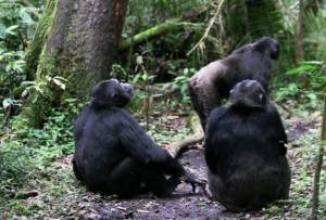 This starts with the briefing about the expectations, rules and regulations to be followed during the trekking process. Here, you are in the company of a tour guide which takes 2-3 hours depending on the location of the chimpanzees. Besides, you will be given 1 hour and an 8m distance to enjoy the presence of these primates. You will learn more about their behaviors, habits as well as taking photos and recording the moments. During the trekking you can also encounter other primates such as baboons, red-tailed, colobus, white and black monkeys.
Bird watching
There are a number of beautiful bird species which are seen along the Kichwamba escarpment. You only need to move along with a pair of binoculars and cameras to take photos of these birds. These include; the African fin foot, Black coucal, Barbets, African mustached warbler. Blue headed bee-eater, Swamp flycatcher, White winged warbler, Flamingos, Shoebill stork, African skimmers, etc.
Nature walks
This is an interesting activity which involves exploring the beautiful scenery and landscapes. While here, you are accompanied by a professional tour guide who is well versed with the different trails. Here, a nature walk can either be done early in the morning or late afternoon. You may spot different primates such as red-tailed, colobus, black and white monkeys and different bird species found within the forest gorge.
Maramagambo Forest
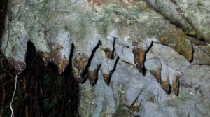
Maramagambo forest is located in the southern part of Queen Elizabeth national park and well known for cave bat experience. The forest is from Kichwamba escarpment all through Lake Edward and its canopy shade is good hiking, bird watching and nature walks. A view point was constructed where you will be able to see bats and big pythons that live in here. Some of the primates found here include; vervet, colobus, red-tailed, L’Hoest monkeys and baboons. Animal species include; giant forest hog, African buffaloes, pygmy antelopes. Bird species such the white napped pigeon, Rwenzori Turaco, forest flycatcher, red tailed bristle among others.
Activities in Maramagambo Forest
Cave bat experience
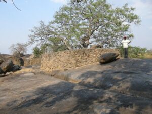
The forest is basically well known for its cave bats with a volcanic tube like caves that attract a given number of bats. As a result, the bats also attract large numbers pythons to this place since they are their source of food. Information about this place circulated after a tourist from Netherlands was believed to have acquired Marburg from the cave bat in this forest. Later, the outbreak led to the closure of the area until a viewing platform was constructed by the American Centre for Disease control.
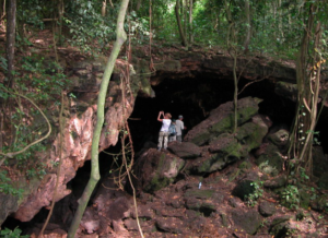 Apart from the bat cave experience, the forest also inhabits primates such as chimpanzees, monkeys and baboons. It also has an historical cave at Nyanzibiri community which is used as a place for sacrifices and cleansing misfortunes. However, the historical cave is also considered as hiding grounds for the past Ugandan presidents during the dictatorial regimes.
Mweya Peninsula
This sector is also known as the heart of Queen Elizabeth national park where the head offices of park are located and the airstrip. It is also where lake Edward bordering Uganda and Democratic Republic of Congo connected to lake George by Kazinga channel are all located. Activities carried out in this sector include; game drives, boat cruise, mongoose tracking, nature walks and birding.
Activities in Mweya Peninsula
Game drives
Game drives in Mweya start from kyamunuka Crater Lake, through the different trails in thick and thorny bushes. Here, you will view animals such as leopards, warthogs, buffaloes, giant forest hogs, hippos, hyenas, giraffes, zebras, etc. Game drives in this sector are also conducted in 3 phases that is in the morning, afternoon and at night. In fact, this is the only sector where you can have morning and night game drives accompanied by an armed ranger. During the night game drive, you will have a view of the nocturnal animals such lions, leopards, civets, etc. You will also encounter different bird species such as kingfishers, Bee-eaters, eagle-owl, not to mention but a few.
Boat cruise
Tourists here may opt for a launch cruise on the Kazinga channel which starts from the landing site near Mweya safari lodge. This generally exposes you to view different mammals along the water banks of Kazinga channel and various numbers of birds. The cruise is conducted twice a day in the morning at 9:00am and afternoon at 2:00pm usually for 3 hours. Some of the mammals seen include; Nile crocodiles, hippos, elephants, monitored lizards, Uganda kobs, etc. Water birds like swamp flycatcher, little bee-eater, sunbird, red capped lark, etc.
Mongoose tracking experience
This is a unique and interesting activity done in Mweya peninsula with these unique animals. While tracking the mongoose, tourists are companied by researchers who do track down the banded mongoose. These basically live in groups of 12 that sleep together at night in a communal underground den. They are characterized by large heads, small ears, long claws and long tails. A maximum of 4 people are allowed to go for tracking which is carried out in the morning hours and afternoon. This gives you an opportunity to record the behaviors of the mongoose, register their weight and size. You can also have an opportunity to see other animals such as elephants, warthogs, buffaloes, antelopes, etc.
When is the best period to visit these sectors?
It is best to visit these sectors in the dry seasons since the roads are dry and not slippery making movements easy. The grasses are also not so long making it easy to spot these animals grazing and others in the fields like the lions. However Queen Elizabeth national park is open for visitors throughout the year.
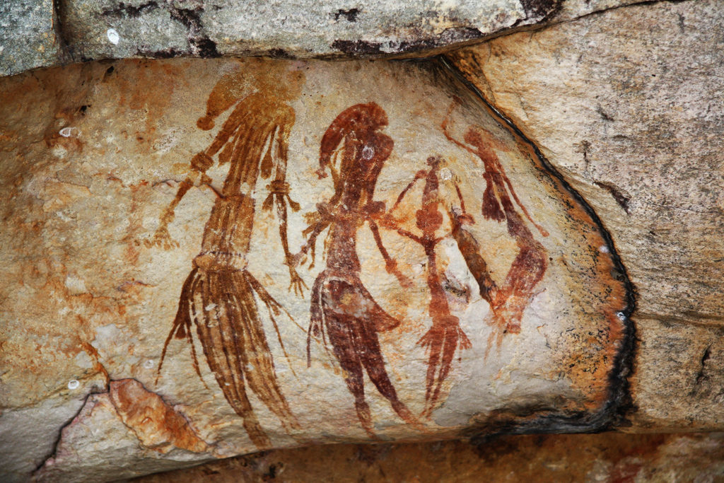
 Panel two is the most impressive one with a 6m high rock face reached via a narrow cleft between two immense boulders. At least 40 sets of red concentric circles are partially visible on the face. At the top right is a very faded painting of three zebras. The most striking naturalistic figures on the panel are two large canoes of which one is about 1.5m long and evidently carrying people. Panel three consists of one white set of concentric circles on the roof of a low rock shelter.
  Iteso tradition does relate that the region’s rock shelters were formerly occupied by a short, light-skinned race of people. Besides, the excavations at Nyero have unearthed several microlithic tools of type not used by the iteso. These are most likely used by hunter gatherers with ethnic and cultural affiliations who were responsible for much of the rock art in southern Africa. Interestingly, the paintings must be above 300 years old.
 Breeding
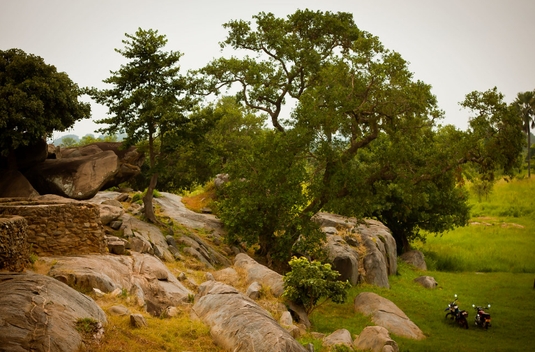
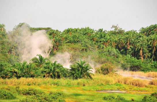
 In fact, the water is so hot in that you can boil an egg and eat it within ten minutes. Since both springs reaches 100 degrees Celsius, it is well known in history that you can cook food with 5-10 minutes. Besides, the park hosts primate species and these include; the red-tailed monkey, grey-cheeked mangabey, etc. Bird species include; hornbills, blue-breasted kingfisher, yellow throated tinkerbird, Frasier’s ant-thrush, etc.
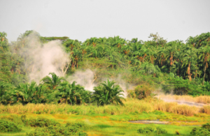 It is said a man named Biteete went hunting in the thick forest but one time never returned home. After three days, the men went out to search for him and at the present day male hot spring. Surprisingly, they only found a spear but no traces of the man. It was assumed he had disappeared from the same spot and they ran back to tell the wife Nyansimbi. A few days later, Nyasimbi mounted the search to clear mysteries around her missing husband. She also disappeared in the forest and only her clothes were found at the present day female hot springs. This was how the two springs became to be known as the male and female hot springs. To-date the Bamaga believe their female ancestors live beneath the female hot spring while their male ancestors live at the male springs.
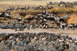 The annual migration of wildlife between
 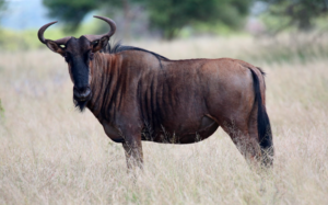 This resulted into the northern and a southern species. The blue wildebeest remained in its original range and changed very little from the ancestral species. However, the black wildebeest changed more as adaptation to its open grassland habitat in the south. The most obvious way of telling the two species apart are the differences in their coloring and in the way their horns are oriented. In East Africa the blue wildebeest is the most abundant big-game species. Some populations perform an annual migration to new grazing grounds but the black wildebeest is merely nomadic.
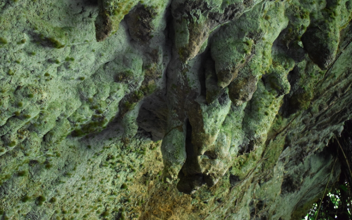
 This milk like substance was created by chemical reaction between water and salt many years ago. As a result, the name “Amabere ga Nyina Mwiru “a local name to mean the breast of Nyinamwiru. In fact, these rocks and caves are called stalagmites and stalactites. A stalagmite is a type of speleothem that rises from the floor of a limestone cave. This is due to the dripping of mineralized solutions and the deposition of calcium carbonate. Besides, the corresponding formation on the ceiling of a cave is known as a stalactite. If these formations grow together, the result is known as a column.
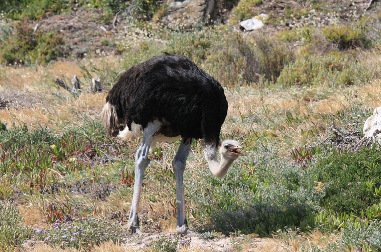
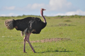 Their running is aided by having just two toes on each foot with the large nail on the larger, inner toe resembling a hoof. When threatened, the ostrich will either hide itself by lying flat against the ground or run if concerned. Although they are powerful, long legs can be formidable weapons. They are therefore capable of killing a human or a potential predator like a lion with a forward kick. Additionally, its feathers are decorative and are also used as feather dusters. Its skin is also used for leather products and its meat is marketed commercially.
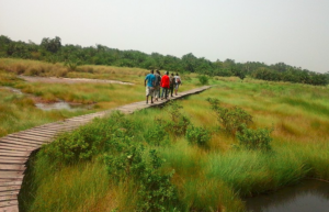
 It comprises of the following islands; the Bugaba, Bufumira, Serinya, Buyova, Bubeke, Funye. On the other, hand Koome Island consists of Luwaji, Damba and Koome (the largest in the group). The Ssese Islands are obviously under the administration of Kalangala district. The Baganda traditionally revere Ssese as the Islands of the gods and in pre-colonial times it was customary for the kings of Buganda to visit the islands. This was done in order to pay tribute to the several balubaale whose main shrines are situated there. These include the shrines to Musisi (spirit of earthquakes) and Wanema (physical handicaps) as well as Mukasa (spirit of the lake).
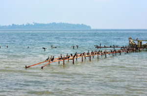 The Island is generally a birders paradise for both water birds and those that live on land. While here, you can spot various bird species and these include; the paradise flycatcher, Great blue Turaco. Shoebill stock, African fish eagle, Palm nut vulture, Marabou stock, Horn bills, Barbets. Robin chats, Crested crane, Weaver birds, African green broadbill, Shelley’s Crimsonwing, Doherty’s, etc. Therefore, don’t forget to pack your birding equipment in order to have the best birding experience.
 The distance from Bwindi to Kihihi Airstrip is about 60 kms and can be driven for about 1.5 hours if the weather is good.If your gorilla trek is in the south of Bwindi or if you are doing gorilla habituation experience, your flights need to land at Kisoro Airstrip. Similarly, if your accommodation is in south Bwindi, Kisoro Airstrip is the best to fly onto for your gorilla trek safari. These include; Clouds Mountain Gorilla Lodge, Nkuringo Gorilla Lodge, Lake Mulehe Gorilla Lodge, Rushaga Gorilla Camp, etc.